4
DIRECTIONS FOR THE DEVELOPMENT OF THE AGRICULTURAL DRONE INDUSTRY
The prolonged battery charging time relative to actual flight duration is a key driver for the development of ultra-fast charging (UFC) technologies. To mitigate the impact of limited flight time, R&D efforts are underway to develop swarm management methods and technologies enabling the use of multiple UAVs simultaneously to accomplish a broad range of tasks in shorter timeframes. Coordinated UAV group operations offer a practical solution for executing large-scale agricultural missions despite existing limitations in payload and flight duration.
Controller systems are being refined to support autonomous operation, reduce the need for manual control, and enhance operational efficiency. These systems integrate and manage various payloads and sensors, ensuring seamless communication and synchronization. As demand for precision agriculture grows, there is a rising need for flight controllers with extended functionality, improved autonomy, efficient payload integration, weather resistance, and embedded geofencing features that monitor not only restricted zones (already implemented by most manufacturers) but also authorized flight zones. This capability—when integrated with air traffic management systems—ensures UAVs remain within approved areas regardless of operator actions. This substantially reduces the risk of hazardous or unauthorized UAV usage and, crucially, enables a reduction in operator qualification and operational certification requirements.
There is also a visible trend in the development of remote controllers (RCs) and control software towards reducing entry barriers for new users in agricultural UAV applications. Improvements in user interface design assist older users or those unfamiliar with UAVs in operating systems more intuitively. Enhancements in control systems enabling single operators to manage multiple drones simultaneously remain a key element in the evolution of this field [37].
Training neural networks to detect typical operator errors and independently verify UAV pre-flight checklists through AI can further reduce risks associated with the deployment of specialized professional drones, such as those used in agriculture.
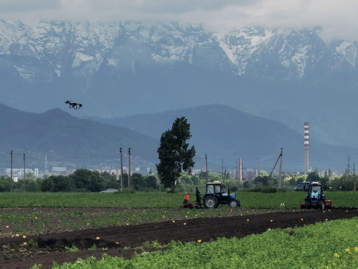
For agricultural UAVs focused on spraying, research is being conducted on precise droplet size calibration and increased spray coverage density. In addition to conventional pressure nozzles, agricultural drones are increasingly adopting centrifugal atomizers. These offer significant advantages, including control over droplet size via rotation speed and suitability for spraying cost-effective soluble powders and suspended substances. Spreading containers for dry materials and aerial seeding are also being improved, particularly in expanding the variety of seed types and granule sizes that can be dispersed with high accuracy (e.g., seeds per square meter). Specialized payload systems for distributing entomophages are also being optimized, expanding the list of beneficial insects that can be effectively deployed using UAVs.
Navigation systems for UAVs in agriculture are improving in two main areas: interference resistance and positioning accuracy. The former ensures reliability in the presence of jamming (e.g., from electronic warfare systems), while the latter guarantees the precision of automated agricultural operations.
AI-generated recommendation maps are increasingly used to determine field boundaries, planting density, and crop growth trends. These maps also support more accurate pesticide and fertilizer application, minimizing environmental impact. AI-driven operations allow users to make informed decisions and implement them efficiently, reducing waste and environmental contamination [30].
Agricultural UAVs typically operate at low altitudes, which presents unique challenges. These drones are less detectable by radar and other active detection methods. Their safety depends heavily on the performance of collision avoidance and terrain-following systems. Some high-speed models fail to adequately respond to rapid terrain changes (e.g., vertical shifts of 2 meters or more), due to inertia and reaction time limitations, particularly at low altitudes (2–3 meters). Consequently, high-speed operation is currently constrained by either increased false positives from obstacle detection sensors or the need to reduce operating speeds to standard levels of around 25 km/h. In the future, improved terrain-following and obstacle avoidance technologies may allow for higher operational speeds without increasing the risk of collisions with power lines, trees, or ravines.
In the long term, the development of UAV technology for agriculture is expected to follow these directions:
● Advancement in battery technology, including increased energy density, faster charging, and higher cycle life;
● Enhanced software and broader integration of neural networks (artificial intelligence). More advanced AI will accelerate the analysis of aerial imagery and delivery of actionable recommendations, while onboard AI systems will reduce the need for human oversight during flight operations;
● Improved structural design to enhance reliability and safety;
● Miniaturization of onboard computing units, sensors, and other electronics while reducing power consumption.
Development of the Regulatory Framework
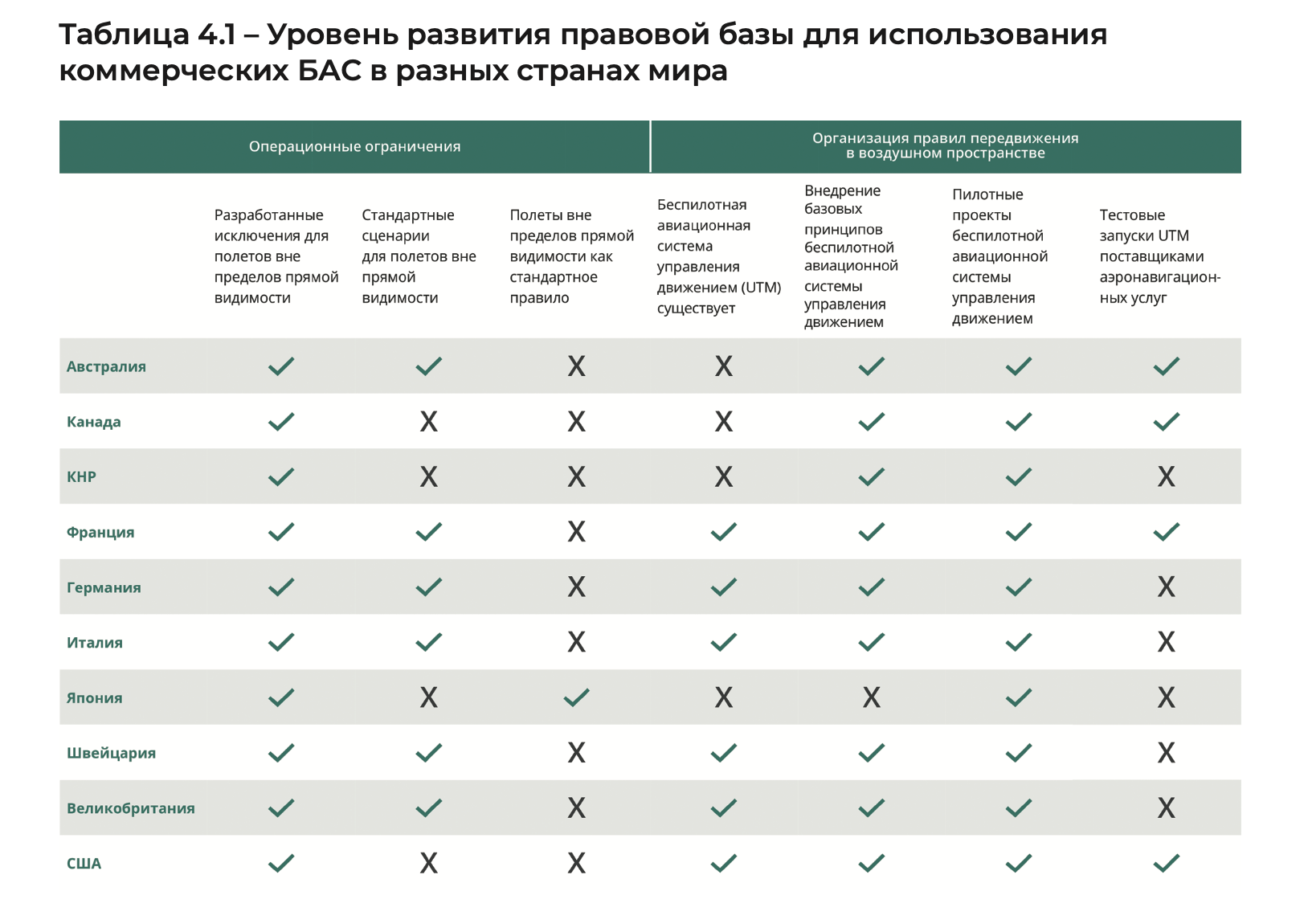
A crucial prerequisite for the advancement of UAV technology in agriculture is the evolution of regulatory and legislative frameworks, which often lag behind the pace of market growth. According to a survey conducted by Drone Industry Insight, 45% of respondents identified regulatory authorities as the primary drivers of drone industry development. Despite considerable progress, regulatory clarity—especially concerning beyond-visual-line-of-sight (BVLOS) operations, remote identification, and unmanned traffic management—remains critical for sectoral growth [40].
Key regulatory aspects define the technical and operational requirements for drones, aimed not only at reducing risks to individuals and other aircraft but also at addressing privacy, security, and data protection concerns. In line with these goals, the European Union Aviation Safety Agency (EASA) introduced in 2019 the “Easy Access Rules for Unmanned Aircraft Systems” (Regulations (EU) 2019/947 and (EU) 2019/945), establishing three categories of UAV operations with different safety requirements:
● The Open category, which does not require prior operational authorization or notification by the UAV operator;
● The Specific category, which requires prior approval from the competent authority due to the need for risk assessment—except in predefined scenarios where operator declaration or a valid operator certificate suffices;
● The Certified category, which mandates UAV certification, a licensed remote pilot, and operator authorization by the competent authority.
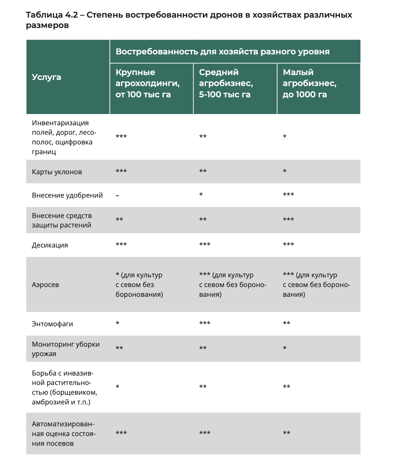
The use of UAVs for inspections and monitoring, as well as agricultural drones, can vary in demand depending on the size of the farms (which can be: *** highly demanded, ** moderately demanded, * low - not in demand). The data on the degree of demand is provided in Table 4.2.